Table of contents
Seitz
to travel
Grisons
Grisons
Between peaks, Schwingern and gorges
The easternmost and largest canton of Switzerland offers three languages and traditional Swiss charisma as well as extremely captivating alpine landscapes. Anyone who has got to know the ups and downs of the Engadine can understand Heidi’s homesickness.
Josef Seitz
06/26/2006
The asphalt windings from the Reschenpass and the Austrian Nauders plunge down into the Inn Valley in a breathtaking manner. It should go on like this. But it only takes a few kilometers until a species that has become rare in Europe suddenly appears in front of the front wheel in Martina: a customs officer. I’m standing in front of the border with Switzerland. The confederate, however, seems satisfied with a short X-ray sample and wordlessly gives way to the Inn upwards.
It leads via Scoul to Guarda. A place that was extensively renovated in the typical Engadine style during the Second World War. State job creation for the craftsmen to help them make ends meet during difficult times. Today Guarda is probably the best preserved village in the Engadine. Painted house facades, old fountains and cobbled streets are reminiscent of times long past. Unfortunately not the prices. A look at the menu of the local hotel restaurant makes my hunger disappear in no time.
Buy complete article
Grisons
Between peaks, Schwingern and gorges
12 pages) as PDF
€ 2.00
Buy now
In the Inn Valley, meanwhile, splendid passes branch off northwards to the Rhine Valley. I leave the Fluela on the left, but the Albula finally falls. The route climbs quickly upwards, leads a few kilometers to the top of the pass through a barren rocky area before winding downhill, becoming significantly narrower, with the viaducts of the Rhaetian Railway always in view. At the bottom the road branches off to Davos. And there it becomes intimate, you touch your pants. When the Swiss get carried away with something like that, there is nothing disreputable about it, it’s sport. Swiss national sport, more precisely: wrestling, a kind of wrestling match in the open air. One of the most traditional is the “Sertigschwinget”, which is held up in the Sertig Valley in the tiny “Dorfli” of the same name.
In order to be able to really grab hold of their trousers, the fighters pull on short leather trousers, and a little later sweaty bodies whirl through the air on a field covered with sawdust and pull dogged fighters on leather and fabric until one day someone lies on their back. The referee declares the winner, you shake hands, and the winner knocks the chips off the back of the loser. Swinging is a matter of honor, even if a shoulder joint can jump out of the pan. On such a day, the world in Sertig-Dorfli offers real Heidiland. Alternating yodelling, accordion or alphorn sounds whiz through the clear alpine air. And by no means just for tourists, but out of tradition. An old lady from the village assures her that her grandfather had already talked about swinging.
Seitz
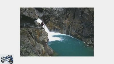
Carved into the stone: the way up the Roflaschlucht gorge.
I drive back in the Sertig Valley and reach significantly higher regions in the neighboring Dischma Valley. Stone and rock now determine the landscape. The cows, who feed the slopes with the tinkling of bells and produce delicious Swiss quality milk, seem to like it. Unfortunately the valley is a dead end, only cow paths continue. But just one mountain range further, the Fluelapass creates the next crossing back into the Inn Valley. The well-developed road climbs in fast curves to 2,383 meters, and at the top the peaks are already glowing in the last rays of sunshine. The descent on the eastern flank is much more bumpy, dipping into the long shadows of the alpine peaks that point down to Zernez.
The Swiss National Park, the oldest in the Alps, begins here. For 90 years nature has acted untouched over an area of 172 square kilometers. For example, the ibex, which was exterminated throughout Switzerland in the 19th century, was able to form new populations. And today they are settling again all over the country, 170 animals in the park alone. The bearded vulture also settled here again a few years ago. Well, who refuses to reside in Switzerland? And what curves through the middle of the protected area? The furnace pass, and that offers a good insight. Dead trees are rotting all around on the mountain slopes, forming the basis for new growth. Quite a messy condition by Swiss standards. In return, a healthy, dense mountain forest with lively ground floor dwellers emerges in nature, left to its own devices. Statistically speaking, 500 million microorganisms can be found in one square meter of the park’s forest floor. Pictures and oversized models in the information center of the national park show real monsters.
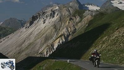
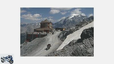
Shortly before the top of the pass, the road leaves the unspoilt area and winds down to Santa Maria, where the Umbrail branches off in the middle of the village, the highest crossing in Switzerland at 2501 meters. A narrow lane on which the Honda climbs up in innumerable tight bends like an ibex. And even master a short section of gravel. Then a run-down border station appears, which has apparently already passed its great days. There is no customs officer to be seen far and wide. Instead, the Stilfser Joch is almost at eye level. I chase them
Africa Twin through the last hairpin bends on number three of all alpine passes. From a proud 2758 meters above sea level I thunder down into the Italian Bormio. Shortly before the village is the junction towards Isolaccia, and I’m on the next pass, the 2291 meter high Passo di Foscagno, towards Livigno. From there, the strip of asphalt runs fairly straight through the valley between green mountain slopes, then adapts to the rough rock behind the border station and skilfully meanders over to Berninastrabe. If I actually wanted to go down to Tirano, I am now drawn up, where Lago Bianco reflects the gray remains of deep-lying glacier tongues.
The perfect backdrop for the Ducati red Bernina Express. At Lago Bianco it stops at the highest train station in Europe that can be reached without gear support. At an altitude of around 2200 meters. The Swiss are proud of their red mountain worm. Rightly so, because a serpentine viaduct was even built in Brusio to overcome the difference in height using a spiral track. The Poschiavo valley at the foot of the Bernina Group belongs to the Italian-speaking part of Switzerland. And the little Poschiavo already exudes Mediterranean flair with its narrow streets and a glamorous piazza next to the church. I ask curiously how such a remote little place comes to have such an elegant appearance. Some of this, I learn, comes from pastry chefs who went abroad in the 19th century and successfully sold their delicacies there. Shortly before Tirano I turn around and start my way back over the Bernina. The east driveway is a dream for fast motorcycles: wide, even curve radii in which the cart whizzes like clockwork.
Grisons (2)
Seitz
There is even a small piece of gravel for the enduro.
A little later, near Sankt Moritz, I reach the Inn and the Upper Engadin again, and thus the Rhaeto-Romanic-speaking area of Graubunden. In the upper part of the valley, the mountains have left space for several lakes. Champferer, Silvaplaner and Silsersee together form the highest lake plateau in the Alps at around 1800 meters. Framed by three-thousand-meter peaks, this part of the Engadine is one of the magnets for Swiss tourists. One of the films about “Heidi” was even shot on Lake Sils … Maloja, which has a few houses, forms the top of the pass and the southern end of the Engadine.
This is where things get really interesting for Honda. The Malojapassstrabe overcomes an almost vertical rockfall on artfully piled hairpin bends. Behind it, in the formerly isolated Bergell or Val Bregaglia, as it is now called again near Italy, ancient mountain villages have been preserved between the pass and the national border. First and foremost, Soglio, made of rock: hunched houses with slate-covered roofs and roughly cobbled streets through which a cow just seems to fit. Petrified past. In fact, a large part of the houses is empty and only acts as a backdrop for day tourists.
A building that also tells of other times is downstairs just before the border in Stampa near Promontogno and takes me back to the confectioners. Castelmur Castle was built by a pastry chef who emigrated to Marseille. The interior design finally makes it clear that business acumen is a typical Swiss quality. There is currently an exhibition on the history of the traveling pastry chef on the upper floor, and there I meet a man whose ancestors came from the industry. He says that the first Swiss confectioners moved to the metropolises of Europe as early as the 17th century and even held the market leadership in the calorie bomb business in Genoa, Paris and Berlin into the 19th century. As earnings decreased and taxes increased, the sweet dream gradually dissolved. World War I and World War II ended the matter for good.
Once again I briefly travel to Italy to tackle the Splugen Pass from the south. Unfortunately, the weather is thwarting my plans, the first drops fall shortly before the top of the pass. The marmot colony on the slope next to the pass road is not disturbed by this. While I squeeze into my rain gear, they scurry around undisturbed. Until at some point they take in my scent, emit warning whistles and suddenly disappear into their holes.
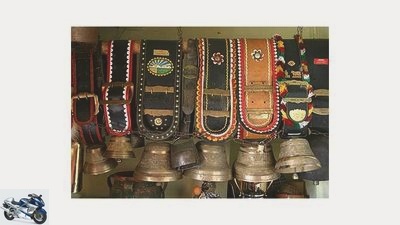
Seitz
So that you not only see the cows, but also hear them …
Behind the Splugen I roll down to the Rheinwald and Hinterrhein, one of the source rivers of the later river, which has already eaten a mighty gorge in the rock: the Rofla Gorge. At the beginning of the century, a certain Christian Pitschen-Melchior blasted the footpath to the waterfall in the once inaccessible gorge into the rock. For seven years he worked with a hand drill for the blast holes as well as a hammer and chisel. The Rofla Gorge is basically just the opening act. The real attraction is a good bit further downstream near Thusis: the Via Mala – evil way. This is what it was called because its dangerous crossing repeatedly resulted in serious accidents and casualties. She had inspired painters and poets, even Goethe was here, and John Knittel’s tragic novel “Via Mala” still captivated our mothers. In the meantime, the threatening-looking, narrow gorge has become one of the biggest attractions in Graubunden, especially as it is still strategically located on one of the country’s main traffic arteries, the San Bernadino Route. Busloads of tourists pulsate during the high season on the narrow stairs to the bottom of the gorge.
Quite different in the significantly quieter valley of the Averserrhein, another branch of the Rhine, which runs to the south-east. The gorges are no less spectacular. The road climbs above the tree line, crosses a few settlements consisting of just a few farms between meadow slopes and ends in Juf – the highest permanently inhabited place in Europe at 2126 meters. A few farmhouses, a pub and lots of happy cows – that’s it. I let the Honda roll back to the Hinterrhein at a leisurely pace, the last pass of my journey already in sight.
The San Bernardino climate divide and tour highlight at the same time. Turn after turn, curve by curve, the sky is getting closer. At the pass crossing, slate knolls polished smooth by wind and weather flank the narrow street. Then the asphalt ribbon winds down into Val Mesolcina. The first palm trees appear on the roadside thirteen kilometers before Bellinzona. Grapevines line up on dry fields, and the mild air of Ticino spreads out together with classic Italian villages. Only the white and red flag that flutters in front of some house fronts reminds us that I am still in Switzerland. When I watch the storm clouds gathering over me while having a cappuccino on Lake Lugano with discomfort, my thoughts are already on the way back. Maybe over the San Bernardino again? Or maybe over the Splugen? Or over to the Maloja? Oh well, it’s best to do all three in a row.
Graubunden (information)
The south-easternmost canton of Switzerland offers a dream area for motorcyclists. Lots of mountain passes cross the alpine chains in Graubunden. In between lies the Umbrail, the highest pass in Switzerland.
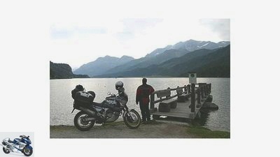
Seitz
Lake Sils in the Upper Engadine with a view of the Alpine panorama.
getting there
The quickest way to get to Graubunden leads past Lake Constance via Lindau and Bregenz to Chur, the more beautiful one via the Fernpass or the Hahntennjoch to the Reschenpass. Our tip: Instead of driving on the main route from the Reschenpass in the direction of Sankt Moritz, it is better to drive a few kilometers up the Reschenpass and only turn into Switzerland in Nauders. The short but crisp descent from Nauders to Martina is very worthwhile.
gastronomy
The Swiss cuisine is excellent, but the prices are rather off-putting. However, many restaurants offer a daily menu, the price of which does not spoil your appetite. Graubunden’s specialty is Bundnerfleisch, air-dried, wafer-thin beef. Another Swiss invention are pizza rosti: Instead of pizza dough, the ingredients are placed on roasted potatoes. The tour through Eastern Switzerland naturally also includes a hearty piece of mountain cheese, which is often still made in the traditional way on alpine pastures.
Stay
Graubunden is one of the holiday regions in Switzerland and the range of overnight accommodations is correspondingly extensive. Even in the high season there is almost always a room at least in hotels and Albergos. The prices start at around fifty to sixty francs per person (breakfast is usually extra) and, depending on the region, there are hardly any upper limits. Overnight stays in old places such as Guarda, where you can often sleep in lovingly renovated houses, are particularly nice. Accommodation in the straw with your own sleeping bag is sometimes offered by farms at relatively low prices. Flats or apartments are often cheaper for several people. Those who like to travel autonomously will find more than twenty campsites in Graubunden, most of which are well-maintained and well-equipped. A list is available on the Internet at www.camping.ch.
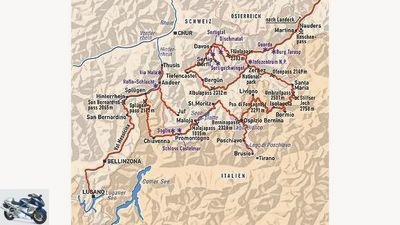
Map: Mairdumont, Maucher
About 700 kilometers, comfortably in four to five days.
Worth seeing
Guarda gives the best impression of a typical old Engadine village. Not far from there is Tarasp Castle above the south bank of the Inn and Castelmur Castle is located near Promontogno in the Italian part of the country. This is especially worth seeing because of its interior. The mountain village of Soglio also gives an impression of former life in Switzerland, information on the Swiss National Park is available from the information center in Zernez. Railway fans can see the route of the Rhaetian Railway over the Albula on a model in the Bergun Museum. If you can set up a schedule, you should visit a wrestling competition. The Sertigschwinget in the Sertig Valley near Davos takes place every year at the beginning of August. The dates will be announced on the Internet on the website of the Swiss Wrestling Association: http://www.esv.ch .
literature
DuMont offers a travel guide exclusively about Graubunden. The handy travel paperback for twelve euros provides very good information about sights, culture and history and even has a decent map at a scale of 1: 315,000 in the appendix.
Otherwise, Michelin sheet No. 553 Regional, Schweiz Sud-Ost is suitable. With a scale of 1: 200,000, even the smallest branch lines can be discovered with it. The general map of Switzerland from Hallwag in 1: 303000 is also well suited for the tour.
information
In Germany: Switzerland Tourism PO Box 16 07 54, 60070 Frankfurt Internet: http://de.myswitzerland.com E-Mail: info.de@switzerland.com, Telephone 00800 100 200 30 (free), Fax 00800 100 200 31 ( free), Monday to Saturday from 8:00 a.m. to 8:00 p.m..
In Switzerland: Graubunden regional office, PO Box, CH-7001 Chur / Switzerland, phone 0041 (0) 81/254 24 24 fax 0041 (0) 81/254 24 00, email: contact@graubuenden.ch, internet: www.graubuenden.ch.
Related articles
-
to travel Northern Turkey Northern Turkey Second home Anyone who gets involved in the hinterland of the Black Sea coast should be able to ride a…
-
to travel India India Girlfriends Six thousand meter peaks with eternal snow, apple trees at an altitude of 3,600 meters, wild cattle and monkeys on the…
-
Motorcycle tour in eastern Switzerland: Appenzell
Iron ham to travel Motorcycle tour in eastern Switzerland: Appenzell Motorcycling in Switzerland Motorbike tour through the Appenzellerland Granted, the…
-
to travel Nepal Nepal Once limit value and back With a 500 Enfield to the eight-thousanders on earth. A journey between wooden sheds and pagoda temples…
-
Seitz to travel Alpine winter tour Alpine winter tour Winter for cold showers When the sun licks the ice off the streets for a short time, the…
-
On the smallest of routes through Germany
Johann to travel On the smallest of routes through Germany On the smallest of routes through Germany 6 ½ days About the daring attempt to conquer the…
-
to travel Mexico Mexico Change of course What to do when a hard winter suddenly arrives in the land of deserts, beaches and volcanoes? Michael Schroder…
-
Extreme tour with BMW R 1150 RT
Gori motorcycles Extreme tour with a BMW R 1150 RT Extreme tour with BMW R 1150 RT 48 hours: the kilometer eater As far as possible in 48 hours. An…
-
Fichtel Mountains – Franconian Forest
to travel Fichtel Mountains / Franconian Forest Fichtel Mountains / Franconian Forest Gentle border area Two forest mountains meet in the northeast…
-
On the smallest paths through Germany, part II
Johann to travel On the smallest paths through Germany, part II On the smallest paths through Germany, part II Is it going to the Baltic Sea somewhere??…